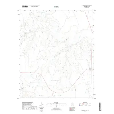
2019 Map of Clairemont West
USGS Topo · Published 2019About this map
Clairemont sits at the eastern edge of this West Texas landscape, where the local road network converges near the banks of the Salt Fork Brazos River. The terrain is defined by the intricate drainage systems of Fourmile Cr and Salt Cr, which carve deep into the Kent County plains. A legacy of early rural development is visible in family and functional landmarks like Schoolhouse Hollow, suggesting the locations of former community centers. Transportation is facilitated by established routes such as Ranch Rd 1231 and a grid of county roads including Co Rd 108, which connect isolated ranching tracts to the central hub at Broadway. The map illustrates the persistent relationship between the arid land and its seasonal watercourses, including Butte Cr.
Find a feature on this map
21 named features on this map. Tap any name to fly to it.
Don’t see what you’re looking for? This feature index may not catch every label — zoom into the map to look around manually.
Map Details
Editions of this 2019 Clairemont West Map
This is the sole edition of this map. No revisions or reprints were ever made.
Other maps of this area

1954 · Lubbock
USGS Topo · 1:250,000

1959 · Girard
USGS Topo · 1:24,000

1968 · Spur SW
USGS Topo · 1:24,000

1968 · White Camp
USGS Topo · 1:24,000

1969 · Cooper Mountain
USGS Topo · 1:24,000

1969 · Clairemont East
USGS Topo · 1:24,000

1969 · Clairemont West
USGS Topo · 1:24,000

1969 · T-O Creek
USGS Topo · 1:24,000
1969 · Gant Hills
USGS Topo · 1:24,000
1969 · Polar
USGS Topo · 1:24,000