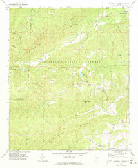
1969 Map of Clairmont Springs
USGS Topo · Published 1973About this map
The Seaboard Coast Line railroad carves a winding path through the high ridges of the Talladega National Forest in this 1969 topographic survey. This corridor of the Alabama hills is defined by the steep elevation of Talladega Mountain and Poe Bridge Mountain, where the Skyway Motorway provides a ridge-top route above scattered rural settlements. Small communities like Clairmont Springs and Chandler Springs are centered around local water sources, while the landscape further south and east is punctuated by country churches including Sardis Ch and Antioch Ch.
Find a feature on this map
42 named features on this map. Tap any name to fly to it.
Don’t see what you’re looking for? This feature index may not catch every label — zoom into the map to look around manually.
Map Details
Editions of this 1969 Clairmont Springs Map
4 editions found
Other maps of this area

1890 · Talladega
USGS Topo · 1:125,000

1891 · Ashland
USGS Topo · 1:125,000

1892 · Talladega
USGS Topo · 1:125,000

1943 · Talladega
USGS Topo · 1:62,500

1944 · Goodwater
USGS Topo · 1:62,500

1946 · Talladega
USGS Topo · 1:62,500

1947 · Goodwater
USGS Topo · 1:62,500

1953 · Birmingham
USGS Topo · 1:250,000

1953 · Atlanta
USGS Topo · 1:250,000

1956 · Birmingham
USGS Topo · 1:250,000