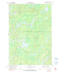
1971 Map of Clam Lake SE
USGS Topo · Published 1990About this map
Chequamegon National Forest dominates this northern Wisconsin landscape, revealing a dense network of waterways within the Shanagolden and Chippewa survey blocks. The area is defined by the winding paths of the Chippewa River and the Moose River, which are fed by numerous tributaries including East Torch River, Hummingbird Creek, and Fishtrap Creek. This 1971 survey shows a landscape almost entirely devoted to timber and conservation, with very few signs of human industrial activity beyond a lone Gravel Pit. The map captures the complex hydrology of the region, where seasonal creeks like Hull Creek and Run Creek carve through the woodland. It provides an essential look at the drainage patterns and untouched forest sections of Ashland County before later developments or changes in forest management.
Find a feature on this map
12 named features on this map. Tap any name to fly to it.
Don’t see what you’re looking for? This feature index may not catch every label — zoom into the map to look around manually.
Map Details
Editions of this 1971 Clam Lake SE Map
2 editions found
Other maps of this area

1941 · Kennedy
USGS Topo · 1:48,000

1942 · Glidden
USGS Topo · 1:48,000

1942 · Clam Lake
USGS Topo · 1:48,000

1944 · Draper
USGS Topo · 1:48,000

1945 · Kennedy
USGS Topo · 1:48,000

1945 · Clam Lake
USGS Topo · 1:48,000

1945 · Glidden
USGS Topo · 1:48,000

1947 · Draper
USGS Topo · 1:48,000

1953 · Ashland
USGS Topo · 1:250,000

1953 · Rice Lake
USGS Topo · 1:250,000