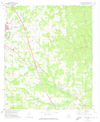
1972 Map of Clanton East
USGS Topo · Published 1974About this map
Clanton serves as the focal point of this Chilton County landscape, where the town's expansion meets the rural drainages of Walnut Creek and Cargle Creek. The 1970s era geography is defined by the heavy infrastructure of the Louisville and Nashville railroad, which dictates the placement of settlements like Falakto, Cooper, and Verbena. A dense network of community landmarks provides significant detail for local historians, including the County High School and Adair School, alongside the County Hospital and Nursing Home. Rural life is anchored by numerous country churches such as Glad Tidings Ch, Sunshine Ch, and Maple Springs Ch. The topography is marked by several Gravel Pits and industrial features like the Filtration Plant and Pumping Stations, reflecting the area's utility and natural resource extraction during this period.
Find a feature on this map
45 named features on this map. Tap any name to fly to it.
Don’t see what you’re looking for? This feature index may not catch every label — zoom into the map to look around manually.
Map Details
Editions of this 1972 Clanton East Map
2 editions found
Other maps of this area

1891 · Clanton
USGS Topo · 1:125,000

1901 · Wetumpka
USGS Topo · 1:125,000

1903 · Wetumpka
USGS Topo · 1:125,000

1953 · Montgomery
USGS Topo · 1:250,000

1956 · Montgomery
USGS Topo · 1:250,000

1957 · Montgomery
USGS Topo · 1:250,000

1959 · Billingsley
USGS Topo · 1:62,500

1959 · Elmore
USGS Topo · 1:62,500
1971 · Mitchell Dam NW
USGS Topo · 1:24,000
1971 · Mitchell Dam
USGS Topo · 1:24,000