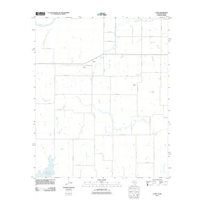
2011 Map of Clara
USGS Topo · Published 2011About this map
Clara and its surrounding ranchlands are defined by the intricate network of watercourses flowing toward the Red River, which forms the northern boundary of this Texas-Oklahoma borderland. The landscape is marked by the industrial presence of the Clara Oil Field, which sits south of the main settlement. Local history and genealogy are anchored at the Clara Cemetery, accessed via Clara Cemetery Rd, while the agrarian heritage of the region is reflected in names like Wyeth School Rd. To the southwest, the North Fork Buffalo Creek Reservoir provides a significant water feature in this otherwise arid environment. The map details a complex drainage system including Wildhorse Creek, Gilbert Creek, and Tenth Cavalry Creek, alongside private landmarks such as Reilly Lake and the Reilly Ranch Loop, offering a clear view of how land ownership and natural hydrology have shaped this part of Wichita County.
Find a feature on this map
46 named features on this map. Tap any name to fly to it.
Don’t see what you’re looking for? This feature index may not catch every label — zoom into the map to look around manually.
Map Details
Editions of this 2011 Clara Map
This is the sole edition of this map. No revisions or reprints were ever made.
Other maps of this area

1915 · Clara
USGS Topo · 1:24,000

1915 · Barwise School
USGS Topo · 1:24,000

1915 · Burkburnett
USGS Topo · 1:24,000

1916 · Iowa Park
USGS Topo · 1:24,000

1916 · Fowlkes
USGS Topo · 1:24,000

1918 · Buckburnett
USGS Topo · 1:31,680

1918 · Barwise School
USGS Topo · 1:31,680

1918 · Clara
USGS Topo · 1:31,680

1918 · Iowa Park
USGS Topo · 1:31,680

1919 · Fowlkes
USGS Topo · 1:31,680