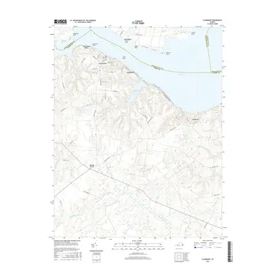
2016 Map of Claremont
USGS Topo · Published 2016About this map
Claremont Manor and the town of Claremont sit atop the bluffs overlooking the wide expanse of the James River, where the geography is defined by a series of prominent river points such as Sloop Point and Tettington Ferry Point. The inland landscape transitions from the residential streets of Claremont, including Virginia Ave and Mansion Ave, into a network of dense wetlands and water bodies. Significant hydrologic features like Sunken Meadow Lake, Cypress Swamp, and Spring Grove Swamp dominate the southern and central portions of the quadrangle. Smaller settlements and historic sites like Spring Grove, Eastover, and Saint Anne's Cem are connected by rural routes such as Swanns Point Rd and Beaverdam Rd, illustrating the intersection of historic riverfront estates and the sprawling natural drainage systems of Tidewater Virginia.
Find a feature on this map
58 named features on this map. Tap any name to fly to it.
Don’t see what you’re looking for? This feature index may not catch every label — zoom into the map to look around manually.
Map Details
Editions of this 2016 Claremont Map
This is the sole edition of this map. No revisions or reprints were ever made.
Other maps of this area

1917 · Toano
USGS Topo · 1:62,500

1918 · Charles City
USGS Topo · 1:62,500

1918 · Toano
USGS Topo · 1:62,500

1919 · Surry
USGS Topo · 1:62,500

1919 · Disputanta
USGS Topo · 1:62,500

1943 · Savedge
USGS Topo · 1:31,680

1943 · Richmond
USGS Topo · 1:250,000

1944 · Waverly
USGS Topo · 1:31,680

1949 · Richmond
USGS Topo · 1:250,000
1952 · Brandon
USGS Topo · 1:24,000