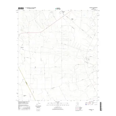
2016 Map of Clareville
USGS Topo · Published 2016About this map
The community of Clareville and the nearby San Pedro Cem anchor this South Texas landscape where the coastal plains begin to ripple with subtle relief. Crisscrossed by a network of farm-to-market roads and county routes, the area is defined by the drainage systems of Aransas Cr, Elm Cr, and Olmos Cr, which carve shallow paths toward the coast. Toward the northeast, the Beeville Municipal Airport and the settlement of Blue Berry Hill show the later 20th-century development of the region near the San Patricio line.
Find a feature on this map
46 named features on this map. Tap any name to fly to it.
Don’t see what you’re looking for? This feature index may not catch every label — zoom into the map to look around manually.
Map Details
Editions of this 2016 Clareville Map
This is the sole edition of this map. No revisions or reprints were ever made.
Other maps of this area

1925 · Mathis No. 2
USGS Topo · 1:48,000

1927 · Mathis
USGS Topo · 1:62,500

1953 · Beeville
USGS Topo · 1:250,000

1954 · Skidmore
USGS Topo · 1:62,500

1954 · Fleming
USGS Topo · 1:62,500

1954 · Mathis
USGS Topo · 1:62,500

1954 · Sinton
USGS Topo · 1:62,500

1956 · Beeville
USGS Topo · 1:250,000

1960 · Beeville
USGS Topo · 1:250,000
1979 · Tynan
USGS Topo · 1:24,000