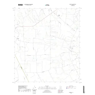
2019 Map of Clareville
USGS Topo · Published 2019About this map
Clareville sits at a geographic crossroads in South Texas, where the drainage systems of the Aransas Cr and Elm Cr shape the landscape. This 2019 survey captures a rural landscape defined by large ranch properties and a network of named county roads, such as Sugarek Ranch Rd and Amador Ramirez Ln, which follow the contours of the terrain. The area's aviation utility is represented by the Beeville Municipal Airport in the northeast, while its local heritage is anchored by the San Pedro Cem. The map's topography reveals a series of intermittent waterways including Little Dry Cr and Dry Cr, alongside named landforms like Weathersby Hollow in the southwest. These features illustrate the drainage patterns essential to the ranching economy of Bee County.
Find a feature on this map
43 named features on this map. Tap any name to fly to it.
Don’t see what you’re looking for? This feature index may not catch every label — zoom into the map to look around manually.
Map Details
Editions of this 2019 Clareville Map
This is the sole edition of this map. No revisions or reprints were ever made.
Other maps of this area

1925 · Mathis No. 2
USGS Topo · 1:48,000

1927 · Mathis
USGS Topo · 1:62,500

1953 · Beeville
USGS Topo · 1:250,000

1954 · Skidmore
USGS Topo · 1:62,500

1954 · Fleming
USGS Topo · 1:62,500

1954 · Mathis
USGS Topo · 1:62,500

1954 · Sinton
USGS Topo · 1:62,500

1956 · Beeville
USGS Topo · 1:250,000

1960 · Beeville
USGS Topo · 1:250,000
1979 · Tynan
USGS Topo · 1:24,000