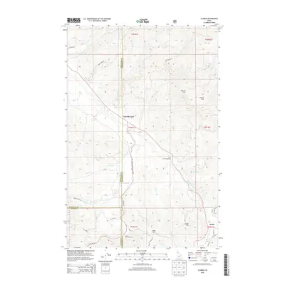
2013 Map of Clarkia
USGS Topo · Published 2013About this map
The Saint Maries River carves through this northern Idaho landscape at the intersection of Shoshone, Benewah, and Latah counties. The settlement of Clarkia sits near the southern edge, serving as a focal point for a region defined by its waterway networks and high timbered ridges. Traces of early 21st-century infrastructure are visible through the extensive network of National Forest Development roads, such as Natl Forest Develop Road 447 Rd and Emerald Creek Rd, which provide access to the area's remote peaks.
Find a feature on this map
49 named features on this map. Tap any name to fly to it.
Don’t see what you’re looking for? This feature index may not catch every label — zoom into the map to look around manually.
Map Details
Editions of this 2013 Clarkia Map
This is the sole edition of this map. No revisions or reprints were ever made.
Other maps of this area

1955 · Pullman
USGS Topo · 1:250,000

1955 · Spokane
USGS Topo · 1:250,000

1958 · Spokane
USGS Topo · 1:250,000

1958 · Pullman
USGS Topo · 1:250,000

1961 · Fernwood
USGS Topo · 1:62,500

1961 · Bovill
USGS Topo · 1:62,500

1969 · Anthony Peak
USGS Topo · 1:24,000
1969 · Merry Creek
USGS Topo · 1:24,000

1969 · Huckleberry Mtn
USGS Topo · 1:24,000

1981 · St Maries
USGS Topo · 1:100,000