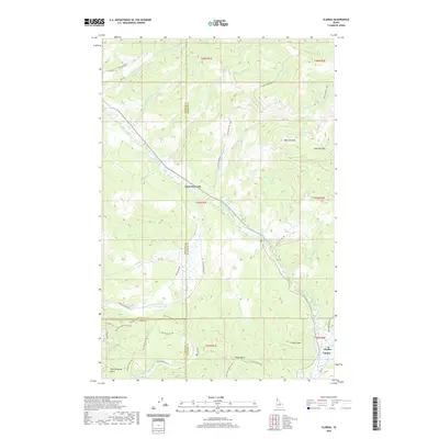
2020 Map of Clarkia
USGS Topo · Published 2020About this map
Clarkia and the surrounding timberlands of the Idaho Panhandle define this 2020 topographical study at the intersection of Shoshone, Benewah, and Latah counties. The Saint Maries River and its W Fork Saint Maries River serve as the primary drainage for this high-country terrain, which is dominated by prominent summits such as Clarkia Peak and West Elk Peak. The map documents a modern landscape shaped by forest management and recreation, evidenced by an extensive network of Forest Service roads including Nat For Dev Rd 447 and Nat For Dev Rd 1948.
Find a feature on this map
52 named features on this map. Tap any name to fly to it.
Don’t see what you’re looking for? This feature index may not catch every label — zoom into the map to look around manually.
Map Details
Editions of this 2020 Clarkia Map
This is the sole edition of this map. No revisions or reprints were ever made.
Other maps of this area

1955 · Pullman
USGS Topo · 1:250,000

1955 · Spokane
USGS Topo · 1:250,000

1958 · Spokane
USGS Topo · 1:250,000

1958 · Pullman
USGS Topo · 1:250,000

1961 · Fernwood
USGS Topo · 1:62,500

1961 · Bovill
USGS Topo · 1:62,500

1969 · Anthony Peak
USGS Topo · 1:24,000
1969 · Merry Creek
USGS Topo · 1:24,000

1969 · Huckleberry Mtn
USGS Topo · 1:24,000

1981 · St Maries
USGS Topo · 1:100,000