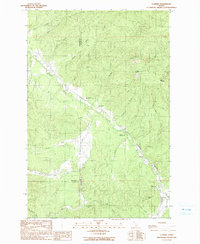
1990 Map of Clarkia
USGS Topo · Published 1991About this map
The St Maries River winds through the heart of the Idaho Panhandle in this 1990 survey, showing the intersection of timber and mining landscapes. The small settlement of Clarkia is positioned near the Ranger Station and Sewage Lagoons, serving as a hub for the surrounding mountainous terrain. Evidence of heavy industrial activity is clear along the West Fork, where significant Dredge Tailings mark the valley floor, indicating a history of mineral extraction.
Find a feature on this map
34 named features on this map. Tap any name to fly to it.
Don’t see what you’re looking for? This feature index may not catch every label — zoom into the map to look around manually.
Map Details
Editions of this 1990 Clarkia Map
This is the sole edition of this map. No revisions or reprints were ever made.
Other maps of this area

1955 · Pullman
USGS Topo · 1:250,000

1955 · Spokane
USGS Topo · 1:250,000

1958 · Spokane
USGS Topo · 1:250,000

1958 · Pullman
USGS Topo · 1:250,000

1961 · Fernwood
USGS Topo · 1:62,500

1961 · Bovill
USGS Topo · 1:62,500

1969 · Anthony Peak
USGS Topo · 1:24,000
1969 · Merry Creek
USGS Topo · 1:24,000

1969 · Huckleberry Mtn
USGS Topo · 1:24,000

1981 · St Maries
USGS Topo · 1:100,000