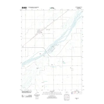
2011 Map of Clarks
USGS Topo · Published 2011About this map
The braided channels of the Platte River define this portion of Merrick County, carving out named landforms such as Bakers Island, Ash Island, and Cottonwood Island. The settlement of Clarks serves as the local hub, organized around a grid that includes the Clarks Post Office and intersections of W Millard St and S Green St. Outside the town center, the landscape is punctuated by water management infrastructure, including the Coover Dam and Dittmer Dam, which support the Coover Reservoir and Dittmer Reservoir. For those tracing local heritage, the Calvary Cemetery and Clarks Cemetery provide specific points of interest north of the town site. The map captures the specialized road network used to navigate the riverbanks, with routes like Morningstar Lake Rd and Hidden Cabin leading directly toward the river's edge.
Find a feature on this map
52 named features on this map. Tap any name to fly to it.
Don’t see what you’re looking for? This feature index may not catch every label — zoom into the map to look around manually.
Map Details
Editions of this 2011 Clarks Map
This is the sole edition of this map. No revisions or reprints were ever made.
Other maps of this area

1896 · Stromsburg
USGS Topo · 1:125,000

1955 · Fremont
USGS Topo · 1:250,000

1957 · Fremont
USGS Topo · 1:250,000

1958 · Fremont
USGS Topo · 1:250,000

1958 · Fullerton
USGS Topo · 1:24,000

1958 · Silver Creek
USGS Topo · 1:24,000

1958 · Havens
USGS Topo · 1:24,000

1962 · Polk
USGS Topo · 1:24,000
1962 · Swedehome
USGS Topo · 1:24,000
1962 · Central City East
USGS Topo · 1:24,000