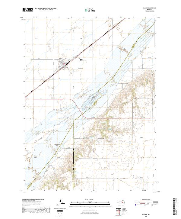
2021 Map of Clarks
USGS Topo · Published 2021About this map
Clarks sits as a central hub on this Nebraska landscape, its street grid defined by names like Beardsley St and George St alongside the vital Union Pacific rail line. The town's local history is anchored by the Clarks Cem and Calvary Cem on its northern edge, while the sprawling braided channels of the Platte River dominate the southern half of the quadrangle. This river system creates a complex network of landmasses including Bakers Island, Ash Island, and the large Prairie Island, reflecting the shifting hydrology of the region. Inland from the river, agricultural water management is evident through several named catchments such as Coover Reservoir, Dittmer Reservoir, and Stevens Reservoir. The map illustrates a strictly organized section-line road system that gives way only to the natural contours of Silver Cr and the river's winding banks.
Find a feature on this map
55 named features on this map. Tap any name to fly to it.
Don’t see what you’re looking for? This feature index may not catch every label — zoom into the map to look around manually.
Map Details
Editions of this 2021 Clarks Map
This is the sole edition of this map. No revisions or reprints were ever made.
Other maps of this area

1896 · Stromsburg
USGS Topo · 1:125,000

1955 · Fremont
USGS Topo · 1:250,000

1957 · Fremont
USGS Topo · 1:250,000

1958 · Fremont
USGS Topo · 1:250,000

1958 · Fullerton
USGS Topo · 1:24,000

1958 · Silver Creek
USGS Topo · 1:24,000

1958 · Havens
USGS Topo · 1:24,000

1962 · Polk
USGS Topo · 1:24,000
1962 · Swedehome
USGS Topo · 1:24,000
1962 · Central City East
USGS Topo · 1:24,000