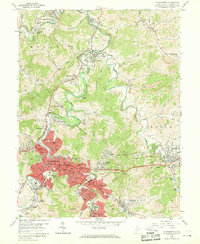
1958 Map of Clarksburg
USGS Topo · Published 1969About this map
The industrial and residential expansion of Clarksburg dominates this mid-century landscape, where the West Fork River carves a winding path through numerous mining and mill towns. The city's footprint extends into suburban and company-town developments such as Stealey, Adamston, and Nutter Fort, while the presence of strip mines and the Laura Lee Mine underscores the region's heavy reliance on the coal industry. Prominent institutional landmarks like the V A Hospital and Pinnickinnick Mtn provide clear geographic orientation amidst the dense network of the Baltimore and Ohio railroad lines.
Find a feature on this map
93 named features on this map. Tap any name to fly to it.
Don’t see what you’re looking for? This feature index may not catch every label — zoom into the map to look around manually.
Map Details
Editions of this 1958 Clarksburg Map
3 editions found
Other maps of this area

1902 · Clarksburg
USGS Topo · 1:62,500

1902 · Fairmont
USGS Topo · 1:62,500

1904 · Philippi
USGS Topo · 1:62,500

1904 · Weston
USGS Topo · 1:62,500

1910 · Clarksburg
USGS Topo · 1:62,500

1923 · Fairmont
USGS Topo · 1:62,500

1923 · Clarksburg
USGS Topo · 1:62,500

1925 · Clarksburg
USGS Topo · 1:62,500

1925 · Philippi
USGS Topo · 1:62,500

1926 · Fairmont
USGS Topo · 1:62,500