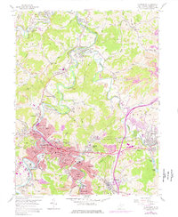
1958 Map of Clarksburg
USGS Topo · Published 1977About this map
Clarksburg and its surrounding industrial satellites appear here at a peak of mid-century development, where the West Fork River carves a deep path through the coal-rich hills of Harrison County. The landscape is defined by a dense concentration of resource extraction and infrastructure, from the Laura Lee Mine in the north to the numerous Strip Mines that dot the ridges. The complex rail network of the Baltimore and Ohio facilitates movement between manufacturing hubs like Spelter, Anmoore, and Nutter Fort. Significant civic landmarks are well-documented, including the V A Hospital, the Orphans Home, and the Drive-in Theater near Meadowbrook. This map captures the integration of urban residential life in neighborhoods like Broad Oaks and North View alongside the heavy industry and mines that sustained the local economy during this era.
Find a feature on this map
90 named features on this map. Tap any name to fly to it.
Don’t see what you’re looking for? This feature index may not catch every label — zoom into the map to look around manually.
Map Details
Editions of this 1958 Clarksburg Map
3 editions found
Other maps of this area

1902 · Clarksburg
USGS Topo · 1:62,500

1902 · Fairmont
USGS Topo · 1:62,500

1904 · Philippi
USGS Topo · 1:62,500

1904 · Weston
USGS Topo · 1:62,500

1910 · Clarksburg
USGS Topo · 1:62,500

1923 · Fairmont
USGS Topo · 1:62,500

1923 · Clarksburg
USGS Topo · 1:62,500

1925 · Clarksburg
USGS Topo · 1:62,500

1925 · Philippi
USGS Topo · 1:62,500

1926 · Fairmont
USGS Topo · 1:62,500