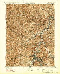
1925 Map of Clarksburg
USGS Topo · Published 1947About this map
The West Fork River valley serves as the industrial and transit artery for Harrison County in this mid-1920s survey, illustrating a landscape defined by the extraction of coal and the expansion of the Baltimore and Ohio railroad. Clarksburg anchors the southern portion of the sheet as a burgeoning urban center, surrounded by satellite communities like Adamston, Despard, and the Fairground Addition. To the north, the river winds through coal-producing settlements such as Enterprise, Hutchinson, and Worthington.
Find a feature on this map
157 named features on this map. Tap any name to fly to it.
Don’t see what you’re looking for? This feature index may not catch every label — zoom into the map to look around manually.
Map Details
Editions of this 1925 Clarksburg Map
3 editions found

Other maps of this area

1902 · Clarksburg
USGS Topo · 1:62,500

1902 · Fairmont
USGS Topo · 1:62,500

1903 · Littleton
USGS Topo · 1:62,500

1904 · Philippi
USGS Topo · 1:62,500

1904 · Blacksville
USGS Topo · 1:62,500

1904 · Weston
USGS Topo · 1:62,500

1904 · Vadis
USGS Topo · 1:62,500

1905 · Mannington
USGS Topo · 1:62,500

1905 · Centerpoint
USGS Topo · 1:62,500

1905 · Littleton
USGS Topo · 1:62,500