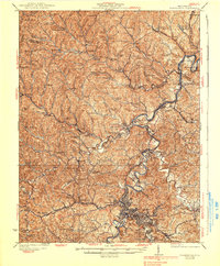
1925 Map of Clarksburg
USGS Topo · Published 1939About this map
Clarksburg stands as a primary railroad and industrial hub along the West Fork River in this 1920s survey of Harrison and Marion Counties. The landscape is defined by the winding tracks of the Baltimore and Ohio RR and the Western Maryland Ry, which connect the urban center of Bridgeport to the outlying mining and milling towns of Lumberport and Enterprise. High-elevation landmarks like Finnickinick Mtn overlook a dense network of rural schools and churches, reflecting the region's early 20th-century social infrastructure.
Find a feature on this map
131 named features on this map. Tap any name to fly to it.
Don’t see what you’re looking for? This feature index may not catch every label — zoom into the map to look around manually.
Map Details
Editions of this 1925 Clarksburg Map
3 editions found

Other maps of this area

1902 · Clarksburg
USGS Topo · 1:62,500

1902 · Fairmont
USGS Topo · 1:62,500

1903 · Littleton
USGS Topo · 1:62,500

1904 · Philippi
USGS Topo · 1:62,500

1904 · Blacksville
USGS Topo · 1:62,500

1904 · Weston
USGS Topo · 1:62,500

1904 · Vadis
USGS Topo · 1:62,500

1905 · Mannington
USGS Topo · 1:62,500

1905 · Centerpoint
USGS Topo · 1:62,500

1905 · Littleton
USGS Topo · 1:62,500