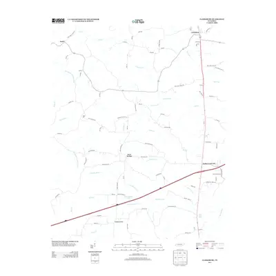
2013 Map of Clarksburg
USGS Topo · Published 2013About this map
Clarksburg and Parker Crossroads anchor this West Tennessee landscape, where a network of rural routes and drainage creeks defines the local geography. The map documents a classic settlement pattern centered on intersections like Union Cross and Rock Springs, with the modern corridor of Interstate 40 cutting through the southern half of the quadrangle. Genealogists will find significant value in the numerous family-named landmarks and historical burial sites, including Hart Cemetery Rd, Coffman Cemetery Rd, and White Cemetery Rd. Water features like the Rutherford Fork Obion River and Elon Douglas Lake dominate the low-lying areas, while the prominent Bible Hill rises above the surrounding terrain. These details capture the transition of a traditional agricultural region into a more connected modern landscape, evidenced by the proximity of long-standing communities to the high-speed transit of the interstate.
Find a feature on this map
91 named features on this map. Tap any name to fly to it.
Don’t see what you’re looking for? This feature index may not catch every label — zoom into the map to look around manually.
Map Details
Editions of this 2013 Clarksburg Map
This is the sole edition of this map. No revisions or reprints were ever made.
Other maps of this area

1936 · Clarksburg
USGS Topo · 1:24,000

1936 · Lexington
USGS Topo · 1:24,000

1936 · Yuma
USGS Topo · 1:24,000

1936 · Center Ridge
USGS Topo · 1:24,000

1936 · Buena Vista
USGS Topo · 1:24,000

1936 · Chesterfield
USGS Topo · 1:24,000

1950 · Yuma
USGS Topo · 1:24,000

1950 · Palmer Shelter
USGS Topo · 1:24,000

1950 · Lexington
USGS Topo · 1:24,000
1950 · Chesterfield
USGS Topo · 1:24,000