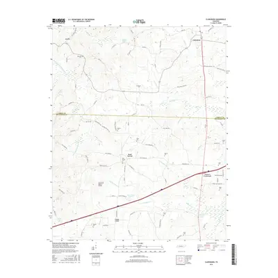
2016 Map of Clarksburg
USGS Topo · Published 2016About this map
Clarksburg stands as the central hub of this West Tennessee landscape, where the headwaters of several river systems emerge from the Tennessee Valley Divide. This geographic spine separates the drainage of the Rutherford Fork Obion River to the west from the Big Sandy River and Big Beaver Cr systems to the east. The 2016 terrain is defined by a dense network of local roads named for prominent families, such as Johnny Cook Rd, Milam Rd, and Cecil Walls Rd, leading to numerous private family burial grounds. Notable genealogy sites including Palestine Cem, White Cem, and Hart Cem are scattered across the rolling hills between the settlements of Jumbo and Union Cross. Near the junction of Interstate 40 and Highway 22, Parker's Crossroads represents the primary commercial corridor in this rural county transition.
Find a feature on this map
92 named features on this map. Tap any name to fly to it.
Don’t see what you’re looking for? This feature index may not catch every label — zoom into the map to look around manually.
Map Details
Editions of this 2016 Clarksburg Map
This is the sole edition of this map. No revisions or reprints were ever made.
Other maps of this area

1936 · Clarksburg
USGS Topo · 1:24,000

1936 · Lexington
USGS Topo · 1:24,000

1936 · Yuma
USGS Topo · 1:24,000

1936 · Center Ridge
USGS Topo · 1:24,000

1936 · Buena Vista
USGS Topo · 1:24,000

1936 · Chesterfield
USGS Topo · 1:24,000

1950 · Yuma
USGS Topo · 1:24,000

1950 · Palmer Shelter
USGS Topo · 1:24,000

1950 · Lexington
USGS Topo · 1:24,000
1950 · Chesterfield
USGS Topo · 1:24,000