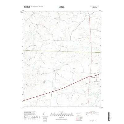
2019 Map of Clarksburg
USGS Topo · Published 2019About this map
Clarksburg and Parker's Crossroads anchor this West Tennessee landscape where the Tennessee Valley Divide separates the watersheds of the Rutherford Fork Obion River and the Big Sandy River. The map reveals a dense network of family-named roads and landmarks, highlighting the rural character of the Carroll and Henderson county line. Numerous small cemeteries, such as Palestine Cem, Rosser Cem, and Hart Cem, are scattered across the terrain, offering significant value for genealogical research. Water features like Elon Douglas Lake and the branching tributaries of Mud Cr and Roan Cr define the local topography. This 2019 survey provides a precise accounting of modern infrastructure alongside these long-established community identifiers, including the localized settlement at Rock Springs and the landmark Mount Ararat Spring.
Find a feature on this map
88 named features on this map. Tap any name to fly to it.
Don’t see what you’re looking for? This feature index may not catch every label — zoom into the map to look around manually.
Map Details
Editions of this 2019 Clarksburg Map
This is the sole edition of this map. No revisions or reprints were ever made.
Other maps of this area

1936 · Clarksburg
USGS Topo · 1:24,000

1936 · Lexington
USGS Topo · 1:24,000

1936 · Yuma
USGS Topo · 1:24,000

1936 · Center Ridge
USGS Topo · 1:24,000

1936 · Buena Vista
USGS Topo · 1:24,000

1936 · Chesterfield
USGS Topo · 1:24,000

1950 · Yuma
USGS Topo · 1:24,000

1950 · Palmer Shelter
USGS Topo · 1:24,000

1950 · Lexington
USGS Topo · 1:24,000
1950 · Chesterfield
USGS Topo · 1:24,000