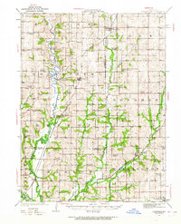
1923 Map of Clarksdale
USGS Topo · Published 1964About this map
The Platte River meanders through Northwest Missouri, anchoring a landscape defined by its river forks and early 20th-century rail connections. At the time of this 1923 survey, the region was densely punctuated by small rural school districts and community churches, reflecting the intensive settlement patterns before school consolidation. Notable crossings like the Wire Bridge and Van Meyer Bridge provided essential links over the river, while the Burlington and Chicago, Rock Island and Pacific railroads facilitated the movement of goods from agricultural hubs like Clarksdale and Helena. Genealogists will find a wealth of specific local landmarks, from the Bowen Cemetery to numerous neighborhood schools like Fountain Blue School and High Prairie Chapel. This map captures the intricate social geography of Andrew, Buchanan, and De Kalb counties during a period when small-scale farming and rail transport dominated the local economy.
Find a feature on this map
80 named features on this map. Tap any name to fly to it.
Don’t see what you’re looking for? This feature index may not catch every label — zoom into the map to look around manually.
Map Details
Editions of this 1923 Clarksdale Map
3 editions found
Other maps of this area

1923 · Clarksdale
USGS Topo · 1:62,500

1923 · Maysville
USGS Topo · 1:62,500

1924 · St. Joseph
USGS Topo · 1:62,500

1925 · Gower
USGS Topo · 1:62,500

1925 · Clarksdale
USGS Topo · 1:62,500

1925 · Plattsburg
USGS Topo · 1:62,500

1925 · Stanberry
USGS Topo · 1:62,500

1925 · Maysville
USGS Topo · 1:62,500

1925 · Darlington
USGS Topo · 1:62,500

1926 · Saint Joseph
USGS Topo · 1:62,500