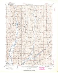
1923 Map of Clarksdale
USGS Topo · Published 1963About this map
The Platte River and its major tributaries, the Third Fork Platte River and the Little Platte River, carve through the landscape of Andrew, Buchanan, and DeKalb counties in this 1923 survey. This era of rural Missouri is defined by a dense network of one-room schoolhouses such as Cherry Grove School, Black Oak School, and Funkhouser School, serving scattered agrarian communities. The river crossings are particularly notable, featuring the Wire Bridge and Van Meter Bridge north of Rochester. Transport in the region is dominated by three major rail lines, including the Chicago Rock Island and Pacific, which connects settlements like Clarksdale and Union Star. Local religious and family history is anchored by landmarks like Platte Chapel, Bethel Church, and the Bowen Cemetery, illustrating the social fabric of the townships before modern consolidation.
Find a feature on this map
83 named features on this map. Tap any name to fly to it.
Don’t see what you’re looking for? This feature index may not catch every label — zoom into the map to look around manually.
Map Details
Editions of this 1923 Clarksdale Map
3 editions found
Other maps of this area

1923 · Clarksdale
USGS Topo · 1:62,500

1923 · Maysville
USGS Topo · 1:62,500

1924 · St. Joseph
USGS Topo · 1:62,500

1925 · Gower
USGS Topo · 1:62,500

1925 · Clarksdale
USGS Topo · 1:62,500

1925 · Plattsburg
USGS Topo · 1:62,500

1925 · Stanberry
USGS Topo · 1:62,500

1925 · Maysville
USGS Topo · 1:62,500

1925 · Darlington
USGS Topo · 1:62,500

1926 · Saint Joseph
USGS Topo · 1:62,500