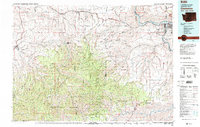
1981 Map of Clarkston
USGS Topo · Published 1981About this map
The Snake River serves as the dominant geographic and economic artery of this region, defining the border between Washington and Idaho at the confluence with the Grande Ronde River. The urban centers of Clarkston and Lewiston mark the northern gateway to the canyonlands, while the southern portion of the sheet is dominated by the high-elevation terrain of the Blue Mountains. This landscape is deeply incised by a complex network of ridges and gulches, including Pow Wah Kee Gulch and Smoothing Iron Ridge, which transition from agricultural plateaus to the protected timberlands of the Umatilla National Forest. The transportation infrastructure of the early 1980s is visible through the routes of the Union Pacific and the Camas Prairie Railroad, reflecting the area's history as a hub for moving goods from the Pataha Valley and surrounding uplands to the river ports.
Find a feature on this map
68 named features on this map. Tap any name to fly to it.
Don’t see what you’re looking for? This feature index may not catch every label — zoom into the map to look around manually.
Map Details
Editions of this 1981 Clarkston Map
2 editions found
Other maps of this area

1910 · Pullman
USGS Topo · 1:125,000

1919 · Walla Walla
USGS Topo · 1:125,000

1921 · Walla Walla
USGS Topo · 1:125,000

1937 · Pomeroy
USGS Topo · 1:96,000

1942 · Pomeroy
USGS Topo · 1:125,000

1943 · Peola
USGS Topo · 1:62,500

1943 · Saddle Butte
USGS Topo · 1:62,500

1944 · Anatone
USGS Topo · 1:62,500

1945 · Clarkston
USGS Topo · 1:62,500

1946 · Saddle Butte
USGS Topo · 1:62,500