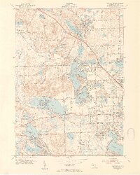
1952 Map of Clarkston
USGS Topo · Published 1954About this map
Pontiac Lake and the upper reaches of the Clinton River dominate this post-war landscape in Oakland County, where suburban development begins to press against established rural settlements. The Grand Trunk Western railroad serves as a primary axis for the region, connecting Clarkston and Waterford while passing the now-abandoned Clarkston Station Sch. The map reveals a transition from traditional lakeside recreation at Windiate Park and Baycourt Camp toward permanent residential expansion, evidenced by the platting of Crescent Lake Estates. Genealogists will find significant detail in the numerous burial grounds, including Lakeview Cemetery and Lakeside Cemetery, while the presence of the Pontiac Municipal Airport and a state Fish Hatchery reflects the diverse civic infrastructure of the early 1950s.
Find a feature on this map
84 named features on this map. Tap any name to fly to it.
Don’t see what you’re looking for? This feature index may not catch every label — zoom into the map to look around manually.
Map Details
Editions of this 1952 Clarkston Map
3 editions found
Other maps of this area

1907 · Pontiac
USGS Topo · 1:62,500

1909 · Milford
USGS Topo · 1:62,500

1920 · Holly
USGS Topo · 1:62,500

1922 · Holly
USGS Topo · 1:62,500

1936 · Wixom
USGS Topo · 1:31,680

1936 · Highland
USGS Topo · 1:31,680

1936 · Clarkston
USGS Topo · 1:31,680

1936 · Walled Lake
USGS Topo · 1:31,680

1936 · Pontiac South
USGS Topo · 1:31,680

1936 · Pontiac North
USGS Topo · 1:31,680
Featured Places
- Waterford Township, MI
- Independence Charter Township, MI
- White Lake Charter Township, MI
- Springfield Charter Township, MI
- Clarkston, MI