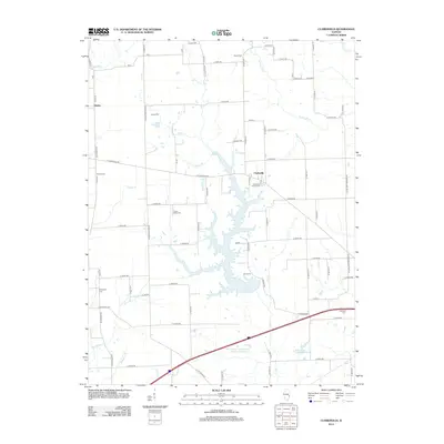
2012 Map of Clarksville
USGS Topo · Published 2012About this map
Clarksville and the surrounding rural landscapes of Clark County are defined by a network of creeks and numerous small burial grounds that dot the prairie terrain. The central feature of this 2012 survey is the sprawling Mill Creek Impoundment Number 2 Reservoir, which dominates the landscape south of the main settlement. For genealogists, the map is remarkably dense with family and community landmarks, from the Clarksville Baptist Cem to more secluded locations like Cupps Cem and Green Moss Cem. The hydrology is equally complex, showing how Mill Creek and its many tributaries, such as Snakeden Br and Brushy Br, have shaped the local geography. The layout of the roads, including E Clarksville Rd and N Cline Orchard Rd, reflects a classic Midwestern section-line grid system, providing clear access to the small community of Doyles in the northwest corner.
Find a feature on this map
83 named features on this map. Tap any name to fly to it.
Don’t see what you’re looking for? This feature index may not catch every label — zoom into the map to look around manually.
Map Details
Editions of this 2012 Clarksville Map
This is the sole edition of this map. No revisions or reprints were ever made.
Other maps of this area

1932 · Marshall
USGS Topo · 1:62,500

1936 · Casey
USGS Topo · 1:48,000

1937 · Marshall
USGS Topo · 1:62,500

1942 · Casey
USGS Topo · 1:62,500

1943 · Casey
USGS Topo · 1:62,500

1946 · Kansas
USGS Topo · 1:62,500

1947 · Paris
USGS Topo · 1:62,500

1949 · Kansas
USGS Topo · 1:62,500

1949 · Paris
USGS Topo · 1:62,500

1953 · Indianapolis
USGS Topo · 1:250,000