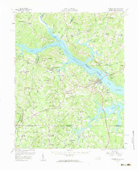
1957 Map of Clarksville
USGS Topo · Published 1959About this map
The Kerr Reservoir dominates this landscape along the Virginia and North Carolina border, where the convergence of the Staunton River and Dan River was transformed by mid-century water management. This 1957 revision captures the region as a recreational and transit hub, featuring the Staunton River State Park and the Occoneechee State Park and Marina. The town of Clarksville serves as a central point for the Southern and Atlantic and Danville rail lines, which cut through a landscape dotted with small agrarian settlements like Buffalo Junction and Hitesburg.
Find a feature on this map
132 named features on this map. Tap any name to fly to it.
Don’t see what you’re looking for? This feature index may not catch every label — zoom into the map to look around manually.
Map Details
Editions of this 1957 Clarksville Map
2 editions found

Other maps of this area

1941 · Clarksville
USGS Topo · 1:48,000

1943 · Clarksville
USGS Topo · 1:62,500

1943 · Roxboro
USGS Topo · 1:62,500

1953 · Oxford
USGS Topo · 1:62,500

1953 · South Boston
USGS Topo · 1:62,500

1953 · Greensboro
USGS Topo · 1:250,000

1954 · Greensboro
USGS Topo · 1:250,000

1954 · Clover
USGS Topo · 1:62,500

1954 · Halifax
USGS Topo · 1:62,500

1955 · Chase City
USGS Topo · 1:62,500