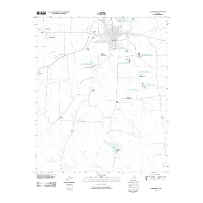
2010 Map of Clarksville
USGS Topo · Published 2010About this map
Clarksville serves as the focal point of this Red River County survey, where the grid of the town site meets the expansive agricultural landscape of northeast Texas. The map illustrates a region defined by its water management and scattered rural communities, including Mabry, Sherry, and Aikin Grove. A notable system of reservoirs, such as Soil Conservation Service Site 12 Reservoir and Soil Conservation Service Site 7 Reservoir, highlights the 20th-century emphasis on flood control and irrigation across the drainage basins of Boggy Creek and Langford Creek. For the local historian, the map preserves the locations of numerous family and community burial grounds, from the New Shamrock Cemetery in the northwest to Pleasant Hill Cemetery further south. The Clarksville-Red River County Airport and the Red River Country Club Dam reflect the mid-century infrastructure supporting the local economy and social life.
Find a feature on this map
64 named features on this map. Tap any name to fly to it.
Don’t see what you’re looking for? This feature index may not catch every label — zoom into the map to look around manually.
Map Details
Editions of this 2010 Clarksville Map
This is the sole edition of this map. No revisions or reprints were ever made.
Other maps of this area

1950 · White Rock
USGS Topo · 1:24,000

1950 · Annona
USGS Topo · 1:24,000

1951 · Annona
USGS Topo · 1:24,000

1951 · White Rock
USGS Topo · 1:24,000

1953 · Texarkana
USGS Topo · 1:250,000

1956 · Texarkana
USGS Topo · 1:250,000

1964 · Bagwell
USGS Topo · 1:24,000

1964 · Cuthand
USGS Topo · 1:24,000

1964 · Bogata
USGS Topo · 1:24,000
1964 · Dimple
USGS Topo · 1:24,000