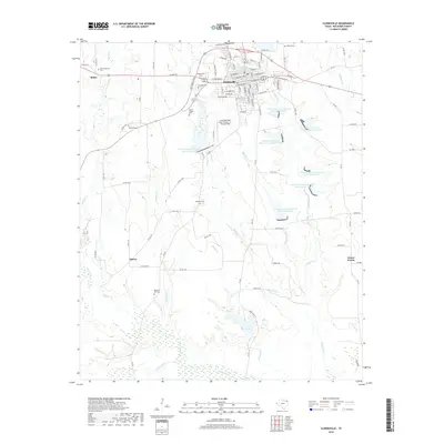
2019 Map of Clarksville
USGS Topo · Published 2019About this map
The town of Clarksville serves as the focal point of this Red River County survey, showing a well-defined street grid featuring W Main St, E Church St, and W Broadway St. The surrounding landscape is characterized by a sophisticated water management network, evidenced by numerous Soil Conservation Service reservoirs, including Soil Conservation Service Site 7 Reservoir and Soil Conservation Service Site 12 Reservoir. These sites, along with South Lake and drainages like Cuthand Cr and Boggy Cr, illustrate the region's focus on agricultural irrigation and flood control.
Find a feature on this map
72 named features on this map. Tap any name to fly to it.
Don’t see what you’re looking for? This feature index may not catch every label — zoom into the map to look around manually.
Map Details
Editions of this 2019 Clarksville Map
This is the sole edition of this map. No revisions or reprints were ever made.
Other maps of this area

1950 · White Rock
USGS Topo · 1:24,000

1950 · Annona
USGS Topo · 1:24,000

1951 · Annona
USGS Topo · 1:24,000

1951 · White Rock
USGS Topo · 1:24,000

1953 · Texarkana
USGS Topo · 1:250,000

1956 · Texarkana
USGS Topo · 1:250,000

1964 · Bagwell
USGS Topo · 1:24,000

1964 · Cuthand
USGS Topo · 1:24,000

1964 · Bogata
USGS Topo · 1:24,000
1964 · Dimple
USGS Topo · 1:24,000