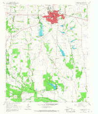
1964 Map of Clarksville
USGS Topo · Published 1968About this map
Clarksville serves as the focal point of this Red River County landscape, showing the town's mid-century footprint centered on the Courthouse and the local County Hospital. The area's educational and historical legacy is prominent, marked by the McKenzie College Historical Monument and various local institutions like the Cheatham Sch and New Century Stadium. The Texas and Pacific railroad cuts across the northern landscape, anchoring the local economy and connecting the county seat to outlying settlements like Mabry and Peters Prairie. Beyond the town limits, the terrain is defined by a dense network of family-named landmarks and watercourses such as Claphand Creek and Cuthand Creek. Numerous rural burial grounds, including McKenzie Cem and Harris Chapel Cem, are documented alongside country churches, reflecting the deep-rooted genealogical history of these Northeast Texas communities before more modern development altered the rural character.
Find a feature on this map
44 named features on this map. Tap any name to fly to it.
Don’t see what you’re looking for? This feature index may not catch every label — zoom into the map to look around manually.
Map Details
Editions of this 1964 Clarksville Map
This is the sole edition of this map. No revisions or reprints were ever made.
Other maps of this area

1950 · White Rock
USGS Topo · 1:24,000

1950 · Annona
USGS Topo · 1:24,000

1951 · Annona
USGS Topo · 1:24,000

1951 · White Rock
USGS Topo · 1:24,000

1953 · Texarkana
USGS Topo · 1:250,000

1956 · Texarkana
USGS Topo · 1:250,000

1964 · Bagwell
USGS Topo · 1:24,000

1964 · Cuthand
USGS Topo · 1:24,000

1964 · Bogata
USGS Topo · 1:24,000
1964 · Dimple
USGS Topo · 1:24,000