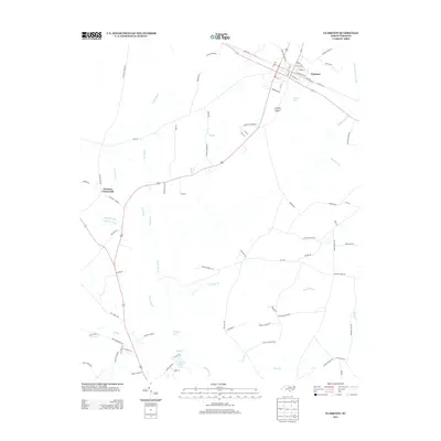
2013 Map of Clarkton
USGS Topo · Published 2013About this map
Clarkton serves as the primary hub in this Bladen County landscape, characterized by a grid of streets such as E Church St and NE Railroad St that reflect its historical development along the rail corridor. The surrounding terrain is defined by an intricate network of wetlands and slow-moving water, including the extensive White Marsh, Slades Swamp, and Brown Marsh Swamp. These features, alongside Elkton Swamp, suggest a low-lying coastal plain environment where agriculture and settlement are dictated by the moisture of the soil.
Find a feature on this map
83 named features on this map. Tap any name to fly to it.
Don’t see what you’re looking for? This feature index may not catch every label — zoom into the map to look around manually.
Map Details
Editions of this 2013 Clarkton Map
This is the sole edition of this map. No revisions or reprints were ever made.
Other maps of this area

1953 · Chadbourn
USGS Topo · 1:62,500

1953 · Florence
USGS Topo · 1:250,000

1954 · Florence
USGS Topo · 1:250,000

1955 · Whiteville
USGS Topo · 1:62,500

1955 · Elizabethtown
USGS Topo · 1:62,500

1957 · Bladenboro
USGS Topo · 1:62,500

1982 · Elizabethtown
USGS Topo · 1:100,000

1986 · Whiteville
USGS Topo · 1:100,000
1986 · Chadbourn
USGS Topo · 1:24,000
1986 · Bladenboro
USGS Topo · 1:24,000