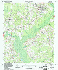
1987 Map of Clarkton
USGS Topo · Published 1987About this map
The town of Clarkton serves as the primary hub of this 1980s landscape, situated where the CSX railroad cuts through the lowlands of the Bladen and Columbus County border. The area is defined by its complex drainage network, where the expansive Brown Marsh Swamp and Half Red Swamp dominate the geography, interspersed with numerous branches like Butler Branch and Mill Branch.
Find a feature on this map
33 named features on this map. Tap any name to fly to it.
Don’t see what you’re looking for? This feature index may not catch every label — zoom into the map to look around manually.
Map Details
Editions of this 1987 Clarkton Map
This is the sole edition of this map. No revisions or reprints were ever made.
Other maps of this area

1953 · Chadbourn
USGS Topo · 1:62,500

1953 · Florence
USGS Topo · 1:250,000

1954 · Florence
USGS Topo · 1:250,000

1955 · Whiteville
USGS Topo · 1:62,500

1955 · Elizabethtown
USGS Topo · 1:62,500

1957 · Bladenboro
USGS Topo · 1:62,500

1982 · Elizabethtown
USGS Topo · 1:100,000

1986 · Whiteville
USGS Topo · 1:100,000
1986 · Chadbourn
USGS Topo · 1:24,000
1986 · Bladenboro
USGS Topo · 1:24,000