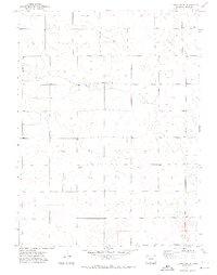
1971 Map of Clarkville SE
USGS Topo · Published 1974About this map
Rock Creek winds through this section of the High Plains in eastern Yuma County, carving a shallow valley across a landscape defined by center-pivot irrigation and cattle ranching. The small settlement of Vonder serves as a local waypoint amidst a grid of section lines and scattered agricultural improvements. This 1971 survey illustrates the rural social fabric of the era through isolated landmarks like Pleasant Valley Ch and Buffalo Grass Ch, which provided community anchors for the surrounding farmsteads. The presence of a Gravel Pit and numerous labeled Wells points to the essential role of water management and local materials in sustaining the local economy during the early 1970s.
Find a feature on this map
9 named features on this map. Tap any name to fly to it.
Don’t see what you’re looking for? This feature index may not catch every label — zoom into the map to look around manually.
Map Details
Editions of this 1971 Clarkville SE Map
2 editions found
Other maps of this area

1954 · Sterling
USGS Topo · 1:250,000

1958 · Sterling
USGS Topo · 1:250,000

1971 · Fiddler Peak
USGS Topo · 1:24,000

1971 · Clarkville NE
USGS Topo · 1:24,000

1971 · Yuma NE
USGS Topo · 1:24,000

1971 · Clarkville SE
USGS Topo · 1:24,000

1971 · Old Baldy
USGS Topo · 1:24,000
1971 · Eckley NW
USGS Topo · 1:24,000

1972 · Clarkville
USGS Topo · 1:24,000

1972 · Clarkville SW
USGS Topo · 1:24,000