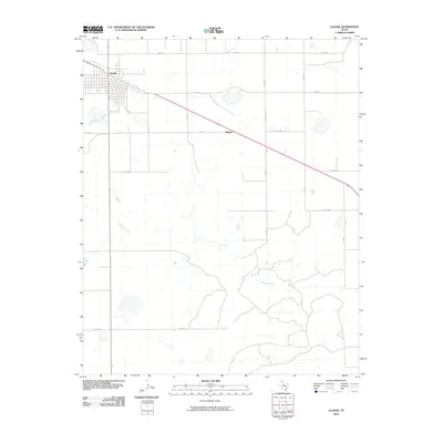
2010 Map of Claude
USGS Topo · Published 2010About this map
Claude serves as the primary hub of this Texas Panhandle landscape, where the town's gridded streets meet the diagonal path of the railway. The map reveals a transition from the structured township of the north to the more complex topography of the south. While the northern half is dominated by an orderly network of section roads like Echo Rd and Fm 1151, the southern portion is defined by the winding course of Mulberry Creek. This drainage system carves into the plains, creating a distinct dendritic pattern that contrasts sharply with the straight lines of the surrounding cattle and agricultural land. Smaller settlements like Malden sit along the main transportation corridor, illustrating the continued importance of the rail line to the rural economy of Armstrong County. Local travel is facilitated by a grid of numbered routes, including Co Rd 16 and Co Rd 17, which connect isolated homesteads to the regional centers.
Find a feature on this map
14 named features on this map. Tap any name to fly to it.
Don’t see what you’re looking for? This feature index may not catch every label — zoom into the map to look around manually.
Map Details
Editions of this 2010 Claude Map
This is the sole edition of this map. No revisions or reprints were ever made.
Other maps of this area

1954 · Amarillo
USGS Topo · 1:250,000

1954 · Plainview
USGS Topo · 1:250,000

1958 · Amarillo
USGS Topo · 1:250,000

1958 · Plainview
USGS Topo · 1:250,000

1960 · Claude
USGS Topo · 1:62,500

1960 · Groom
USGS Topo · 1:62,500

1963 · Blue Hole Springs
USGS Topo · 1:24,000

1963 · Luttrell Springs
USGS Topo · 1:24,000

1963 · Luttrell Springs NE
USGS Topo · 1:24,000
1983 · Lark
USGS Topo · 1:24,000