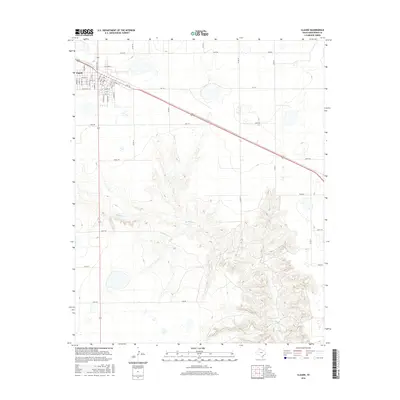
2016 Map of Claude
USGS Topo · Published 2016About this map
The town of Claude serves as the focal point of this Armstrong County landscape, where the rectilinear street grid of the settlement transitions sharply into the expansive ranching and farming lands of the Texas Panhandle. Located in the upper corner of the map, the town's layout is defined by historical thoroughfares like Orient St and numbered streets, intersected by the primary rail and highway corridor. To the south and east, the terrain descends into the complex drainage systems of Mulberry Cr, where the flat plains give way to a network of winding draws and elevation changes. This contrast between the ordered townsite and the deep, branching topography of the creek basin illustrates the geographic divide that dictated local development. A extensive network of rural routes, including Hotel Rd and India Rd, provides a framework for understanding land use and property access across these high plains.
Find a feature on this map
26 named features on this map. Tap any name to fly to it.
Don’t see what you’re looking for? This feature index may not catch every label — zoom into the map to look around manually.
Map Details
Editions of this 2016 Claude Map
This is the sole edition of this map. No revisions or reprints were ever made.
Other maps of this area

1954 · Amarillo
USGS Topo · 1:250,000

1954 · Plainview
USGS Topo · 1:250,000

1958 · Amarillo
USGS Topo · 1:250,000

1958 · Plainview
USGS Topo · 1:250,000

1960 · Claude
USGS Topo · 1:62,500

1960 · Groom
USGS Topo · 1:62,500

1963 · Blue Hole Springs
USGS Topo · 1:24,000

1963 · Luttrell Springs
USGS Topo · 1:24,000

1963 · Luttrell Springs NE
USGS Topo · 1:24,000
1983 · Lark
USGS Topo · 1:24,000