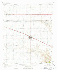
1960 Map of Claude
USGS Topo · Published 1978About this map
Claude serves as the focal point of this High Plains landscape, situated at the junction of the Fort Worth and Denver railroad and significant regional roadways. The terrain transitions from the level plateaus around Conway to the deeply incised drainage of Mulberry Creek in the south. This 1960 survey illustrates the vital role of heavy rail transport in the Texas Panhandle, with the Chicago Rock Island and Pacific line traversing the northern section of the quadrangle. The map reveals a land defined by its watercourses, including the headwaters of the Salt Fork Red River and McClellan Creek. Local infrastructure, such as the Microwave Sta and several quarries, points to the mid-century industrial and communication needs of Armstrong County. Genealogists can also locate the Claude Cem just west of the main settlement.
Find a feature on this map
12 named features on this map. Tap any name to fly to it.
Don’t see what you’re looking for? This feature index may not catch every label — zoom into the map to look around manually.
Map Details
Editions of this 1960 Claude Map
2 editions found
Other maps of this area

1953 · Sevenmile Basin
USGS Topo · 1:24,000

1954 · Amarillo
USGS Topo · 1:250,000

1954 · Plainview
USGS Topo · 1:250,000

1956 · Washburn
USGS Topo · 1:24,000

1958 · Amarillo
USGS Topo · 1:250,000

1958 · Plainview
USGS Topo · 1:250,000

1960 · Fairview
USGS Topo · 1:24,000

1960 · Claude
USGS Topo · 1:62,500

1960 · Groom
USGS Topo · 1:62,500

1960 · Wayside
USGS Topo · 1:62,500