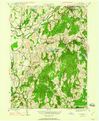
1947 Map of Claverack
USGS Topo · Published 1980About this map
Claverack and Philmont anchor this mid-1940s landscape, where industrial remnants and rural hamlets meet the rising elevations of the Taconic region. The area is defined by a dense network of waterways, including Claverack Creek and Agawamuck Creek, which powered local industry at sites like Red Mills and Glenco Mills. Significant elevation changes are marked by High Falls near Philmont and Buttermilk Falls further west, illustrating the water power that once drove the region's economy.
Find a feature on this map
40 named features on this map. Tap any name to fly to it.
Don’t see what you’re looking for? This feature index may not catch every label — zoom into the map to look around manually.
Map Details
Editions of this 1947 Claverack Map
3 editions found
Other maps of this area

1893 · Coxsackie
USGS Topo · 1:62,500

1894 · Coxsackie
USGS Topo · 1:62,500

1895 · Catskill
USGS Topo · 1:62,500

1902 · Copake
USGS Topo · 1:62,500

1903 · Kinderhook
USGS Topo · 1:62,500

1904 · Copake
USGS Topo · 1:62,500

1929 · Coxsackie
USGS Topo · 1:62,500

1933 · Kinderhook
USGS Topo · 1:62,500

1934 · Catskill
USGS Topo · 1:62,500

1938 · Catskill
USGS Topo · 1:62,500