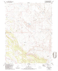
1986 Map of Clay Buttes
USGS Topo · Published 1986About this map
Clay Buttes rise above a landscape defined by an intricate network of seasonal drainages in this mid-1980s Moffat County survey. The terrain is dominated by the sprawling Sand Wash and its various tributaries, including the North Fork Sand Wash and South Sand Wash. Water management for livestock or local needs is evident at the Clay Buttes Reservoir and Two Bar Spring, which serve as vital points in this arid environment. The naming of features like Pigpen Hill, Vaughn Draw, and Sheepherder Springs Draw reflects a history of local land use, likely tied to the region's ranching heritage. Several Drill Hole locations and a Corral scattered throughout the quadrangle further suggest a landscape balanced between resource exploration and traditional agricultural pursuits.
Find a feature on this map
15 named features on this map. Tap any name to fly to it.
Don’t see what you’re looking for? This feature index may not catch every label — zoom into the map to look around manually.
Map Details
Editions of this 1986 Clay Buttes Map
This is the sole edition of this map. No revisions or reprints were ever made.
Other maps of this area

1954 · Vernal
USGS Topo · 1:250,000

1958 · Vernal
USGS Topo · 1:250,000

1960 · Vernal
USGS Topo · 1:250,000

1960 · Lone Mountain
USGS Topo · 1:62,500

1966 · G Spring
USGS Topo · 1:24,000
1966 · Limestone Hill
USGS Topo · 1:24,000

1966 · Sheephead Basin
USGS Topo · 1:24,000

1969 · Sheepherder Springs
USGS Topo · 1:24,000
1969 · Lang Spring
USGS Topo · 1:24,000
1979 · Canyon of Lodore
USGS Topo · 1:100,000