1969 Map of Sheepherder Springs
USGS Topo · Published 1972About this map
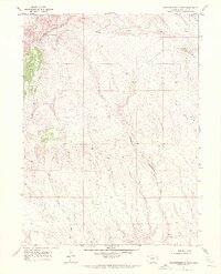
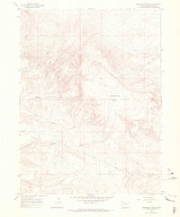
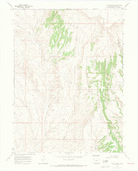
Vermillion Bluffs dominate the northern landscape of this Moffat County terrain, where high-altitude ridges and deep drainage systems define the character of the land in the late 1960s. The prominent Lookout Mtn stands as a primary landmark overlooking a complex network of seasonal watercourses, including the North Fork Sand Wash and Yellow Cat Wash. This area is shaped by its drainage patterns, most notably the Sheepherder Springs Draw which flows toward the southern boundary near Twin Buttes. The presence of a Drill Hole in the northern reaches, near Lake Draw, indicates early resource exploration in this arid reach of Colorado. Sheepherder Springs itself serves as a vital water point in an otherwise dry and dissected topography, illustrating the essential relationship between water sources and land use in the high desert.
Find a feature on this map
9 named features on this map. Tap any name to fly to it.
Don’t see what you’re looking for? This feature index may not catch every label — zoom into the map to look around manually.
Map Details
Editions of this 1969 Sheepherder Springs Map
2 editions found
Other maps of this area

1954 · Vernal
USGS Topo · 1:250,000

1958 · Vernal
USGS Topo · 1:250,000

1960 · Vernal
USGS Topo · 1:250,000
1960 · Lone Mountain
USGS Topo · 1:62,500
1966 · G Spring
USGS Topo · 1:24,000
1966 · Sheephead Basin
USGS Topo · 1:24,000
1966 · Hiawatha
USGS Topo · 1:24,000
1969 · Coffeepot Spring
USGS Topo · 1:24,000
1969 · Powder Wash
USGS Topo · 1:24,000
1969 · Lang Spring
USGS Topo · 1:24,000