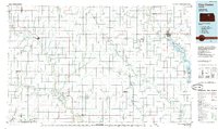
1985 Map of Clay Center
USGS Topo · Published 1985About this map
The Republican River and Solomon River valleys dominate this 1980s landscape, illustrating the agricultural and water-management patterns of North Central Kansas. The eastern edge is defined by the expansive Milford Lake, where the shoreline reaches past Wakefield and the former site of Broughton. These waterways served as the primary conduits for regional growth, supporting a network of small grain-handling towns like Minneapolis, Miltonvale, and Glasco.
Find a feature on this map
102 named features on this map. Tap any name to fly to it.
Don’t see what you’re looking for? This feature index may not catch every label — zoom into the map to look around manually.
Map Details
Editions of this 1985 Clay Center Map
2 editions found
Other maps of this area

1886 · Junction City
USGS Topo · 1:125,000

1889 · Marysville
USGS Topo · 1:125,000

1889 · Junction City
USGS Topo · 1:125,000

1889 · Abilene
USGS Topo · 1:125,000

1889 · Parkerville
USGS Topo · 1:125,000

1891 · Clay Center
USGS Topo · 1:125,000

1892 · Concordia
USGS Topo · 1:125,000

1892 · Salina
USGS Topo · 1:125,000

1892 · Minneapolis
USGS Topo · 1:125,000

1893 · Washington
USGS Topo · 1:125,000