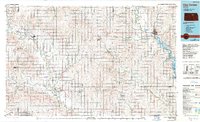
1985 Map of Clay Center
USGS Topo · Published 1990About this map
The Republican River and Solomon River valleys define this mid-1980s landscape across north-central Kansas, where agricultural grids meet the waters of Milford Lake. This survey captures the region's transport network anchored by the Union Pacific System railroad, which connects several well-established grain-handling communities. Centered on Clay Center, the map details a rural landscape transitioning toward conservation and recreation, most notably at the Ottawa State Game Lake and Wildlife Area. Genealogists and local historians can trace the precise boundaries of numerous townships such as Sherman, Garfield, and Blaine, while also locating landmarks like Twin Mounds and Table Mounds. Smaller settlements, including Miltonvale, Glasco, and Delphos, are shown with their proximity to creek systems like Chapman Creek and Pipe Creek, illustrating the historical reliance on these waterways for early settlement and industry.
Find a feature on this map
111 named features on this map. Tap any name to fly to it.
Don’t see what you’re looking for? This feature index may not catch every label — zoom into the map to look around manually.
Map Details
Editions of this 1985 Clay Center Map
2 editions found
Other maps of this area

1886 · Junction City
USGS Topo · 1:125,000

1889 · Marysville
USGS Topo · 1:125,000

1889 · Junction City
USGS Topo · 1:125,000

1889 · Abilene
USGS Topo · 1:125,000

1889 · Parkerville
USGS Topo · 1:125,000

1891 · Clay Center
USGS Topo · 1:125,000

1892 · Concordia
USGS Topo · 1:125,000

1892 · Salina
USGS Topo · 1:125,000

1892 · Minneapolis
USGS Topo · 1:125,000

1893 · Washington
USGS Topo · 1:125,000