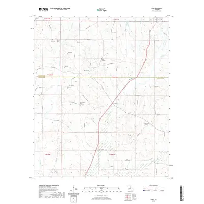
2020 Map of Clay
USGS Topo · Published 2020About this map
Cypress Bayou and its many tributaries, including Sugar Cr and Redwine Cr, flow through this northern Louisiana landscape where Lincoln Parish meets Jackson Parish. Small, scattered communities like Woodville, Clay, and Ansley serve as focal points for a rural road network that includes Old State Rd and the more modern highway corridor. The area's genealogical depth is evident in the dense distribution of burial grounds, ranging from established church sites like New Prosperity Baptist Church Cem and Wesley Chapel Cem to smaller family plots such as the Bond Family Cem and Smith Family Cem. These sites, along with the Wilson Marker, suggest a long history of family land stewardship. The terrain is defined by low-lying wetlands and creek bottoms, particularly along the Shepherd Cr and Barner Springs Cr drainages.
Find a feature on this map
68 named features on this map. Tap any name to fly to it.
Don’t see what you’re looking for? This feature index may not catch every label — zoom into the map to look around manually.
Map Details
Editions of this 2020 Clay Map
This is the sole edition of this map. No revisions or reprints were ever made.
Other maps of this area

1947 · Bienville
USGS Topo · 1:62,500

1949 · Bienville
USGS Topo · 1:62,500

1950 · Ruston
USGS Topo · 1:62,500

1950 · Arcadia
USGS Topo · 1:62,500

1951 · Arcadia
USGS Topo · 1:62,500

1951 · Ruston
USGS Topo · 1:62,500

1953 · Hodge
USGS Topo · 1:62,500

1955 · Shreveport
USGS Topo · 1:250,000

1956 · Shreveport
USGS Topo · 1:250,000

1984 · Shreveport
USGS Topo · 1:250,000