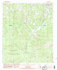
1994 Map of Clay
USGS Topo · Published 1994About this map
Ruston and its southern outskirts define the northern edge of this North Louisiana landscape, where the rolling timberlands of the Lincoln Parish Jackson Parish line meet. The topography is dominated by a complex network of waterways, including Redwine Creek, Barnet Springs Creek, and the winding course of Bayou Cypress. These streams bisect a region defined by industrial and recreational land use, ranging from a local Sand Pit to the expansive State Wildlife Management Area in the south.
Find a feature on this map
18 named features on this map. Tap any name to fly to it.
Don’t see what you’re looking for? This feature index may not catch every label — zoom into the map to look around manually.
Map Details
Editions of this 1994 Clay Map
This is the sole edition of this map. No revisions or reprints were ever made.
Other maps of this area

1947 · Bienville
USGS Topo · 1:62,500

1949 · Bienville
USGS Topo · 1:62,500

1950 · Ruston
USGS Topo · 1:62,500

1950 · Arcadia
USGS Topo · 1:62,500

1951 · Arcadia
USGS Topo · 1:62,500

1951 · Ruston
USGS Topo · 1:62,500

1953 · Hodge
USGS Topo · 1:62,500

1955 · Shreveport
USGS Topo · 1:250,000

1956 · Shreveport
USGS Topo · 1:250,000

1984 · Shreveport
USGS Topo · 1:250,000