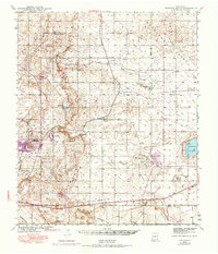
1942 Map of Clayton Basin
USGS Topo · Published 1974About this map
Clayton Basin defines this high desert landscape along the border of Eddy and Lea counties, where industrial activity and ranching meet. The Potash Co of America Mine stands as a significant industrial landmark in the west, while a long-distance Pipeline and the southern tracks of the Atchison Topeka and Santa Fe railroad underscore the regional infrastructure of the mid-20th century.
Find a feature on this map
23 named features on this map. Tap any name to fly to it.
Don’t see what you’re looking for? This feature index may not catch every label — zoom into the map to look around manually.
Map Details
Editions of this 1942 Clayton Basin Map
2 editions found
Other maps of this area

1939 · Carlsbad
USGS Topo · 1:62,500

1939 · Nash Draw
USGS Topo · 1:62,500

1942 · Clayton Basin
USGS Topo · 1:62,500

1943 · Carlsbad
USGS Topo · 1:62,500

1943 · Clayton Basin
USGS Topo · 1:62,500

1943 · Oil City
USGS Topo · 1:62,500

1943 · Nash Draw
USGS Topo · 1:62,500

1954 · Carlsbad
USGS Topo · 1:250,000

1954 · Hobbs
USGS Topo · 1:250,000

1955 · Red Lake SE
USGS Topo · 1:24,000