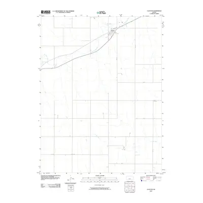
2009 Map of Clayton
USGS Topo · Published 2009About this map
Clayton serves as the primary focal point of this Norton County landscape, situated where the high plains are dissected by the winding course of Prairie Dog Creek. The town's grid is oriented around its transportation roots, with street names like Railroad Ave and Kansas Ave defining the local geography. To the east, the rural character of the region is evident in the presence of the Gettis Cemetery, providing a specific point of interest for genealogical research in this part of Northwest Kansas. The terrain is further defined by a series of drainage systems, including Plum Creek, Big Timber Creek, and Elk Creek, which carve gentle valleys across the agricultural sections. This survey provides a clear view of the section-line road network, including routes like Co Rd 352 and Rd W-13, which organize the homesteads and fields surrounding the central settlement.
Find a feature on this map
17 named features on this map. Tap any name to fly to it.
Don’t see what you’re looking for? This feature index may not catch every label — zoom into the map to look around manually.
Map Details
Editions of this 2009 Clayton Map
This is the sole edition of this map. No revisions or reprints were ever made.
Other maps of this area

1951 · Norcatur
USGS Topo · 1:62,500

1951 · Kanona
USGS Topo · 1:62,500

1954 · Goodland
USGS Topo · 1:250,000

1956 · Goodland
USGS Topo · 1:250,000

1957 · Goodland
USGS Topo · 1:250,000

1965 · Kanona SE
USGS Topo · 1:24,000

1978 · Clayton SW
USGS Topo · 1:24,000

1978 · Clayton
USGS Topo · 1:24,000
1978 · Jennings
USGS Topo · 1:24,000

1978 · Allison
USGS Topo · 1:24,000