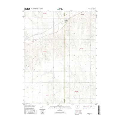
2015 Map of Clayton
USGS Topo · Published 2015About this map
The settlement of Clayton straddles the Decatur Co Norton Co line, serving as a focal point for this rural Kansas landscape during the mid-2010s. Located at the intersection of Main St and Kansas Ave, the town acts as a central hub for the surrounding agricultural sections. The drainage patterns of the high plains are clearly defined by Prairie Dog Cr and its tributaries, Plum Cr and Elk Cr, which carve subtle valleys across the township and range grid. Genealogists and local historians can locate the Gettis Cem situated on the eastern edge of the quadrangle near Rd W-13. The map detail captures the precise layout of the county road system, including throughways like Road S and Road W, reflecting the enduring organization of the Kansas prairie.
Find a feature on this map
33 named features on this map. Tap any name to fly to it.
Don’t see what you’re looking for? This feature index may not catch every label — zoom into the map to look around manually.
Map Details
Editions of this 2015 Clayton Map
This is the sole edition of this map. No revisions or reprints were ever made.
Other maps of this area

1951 · Norcatur
USGS Topo · 1:62,500

1951 · Kanona
USGS Topo · 1:62,500

1954 · Goodland
USGS Topo · 1:250,000

1956 · Goodland
USGS Topo · 1:250,000

1957 · Goodland
USGS Topo · 1:250,000

1965 · Kanona SE
USGS Topo · 1:24,000

1978 · Clayton SW
USGS Topo · 1:24,000

1978 · Clayton
USGS Topo · 1:24,000
1978 · Jennings
USGS Topo · 1:24,000

1978 · Allison
USGS Topo · 1:24,000