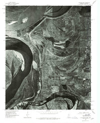
1975 Map of Clayton NW
USGS Topo · Published 1976About this map
The Mississippi River dominates this 1975 orthophotoquad, capturing the shifting dynamics of the delta landscape along the Arkansas-Mississippi border. Unlike traditional topographic maps, this aerial imagery provides a direct look at the intricate field patterns and flood-control infrastructure of the mid-1970s. The settlement of Austin sits near the riverbanks, while the community of Evansville is positioned further inland, adjacent to the curving shore of Beaverdam Lake. The presence of Fox Island and the expansive oxbow remnants illustrate the historical migration of the river channel over time. For genealogists and local historians, the map preserves the exact layout of roads and agricultural tracts near Tunica before later decades of modernization and land-use changes altered the rural character of the region.
Find a feature on this map
6 named features on this map. Tap any name to fly to it.
Don’t see what you’re looking for? This feature index may not catch every label — zoom into the map to look around manually.
Map Details
Editions of this 1975 Clayton NW Map
This is the sole edition of this map. No revisions or reprints were ever made.
Other maps of this area

1908 · Dundee
USGS Topo · 1:24,000

1908 · Hollywood
USGS Topo · 1:24,000

1908 · Walnut Lake
USGS Topo · 1:24,000

1910 · Dundee
USGS Topo · 1:31,680

1910 · Walnut Lake
USGS Topo · 1:31,680

1913 · Hollywood
USGS Topo · 1:31,680

1931 · Horseshoe Lake
USGS Topo · 1:62,500

1939 · Clayton
USGS Topo · 1:62,500

1939 · Horseshoe Lake
USGS Topo · 1:62,500

1939 · Park Place
USGS Topo · 1:62,500