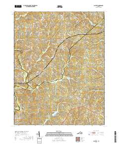
2019 Map of Clayville
USGS Topo · Published 2019About this map
The Appomattox River winds through this central Virginia landscape, forming a natural border between Powhatan, Amelia, and Chesterfield counties. This rural region is defined by a network of established crossroads and small settlements, including Genito, Clayville, and Moseley. Local genealogy is well-represented through landmarks like Grace Cem and Liberty Cem, alongside the prominent Skinquarter Baptist Church near the community of Skinquarter. The drainage patterns are clearly visible, with Skinquarter Creek, Butterwood Cr, and Goode Cr carving out the terrain as they flow toward the river. Residential developments like Graceland Dr and Winterbrook Ct indicate modern growth within a traditionally agricultural area, while the preservation of place names like Pilkinton and Mattoax maintains a connection to the long-standing community identities of the region.
Find a feature on this map
91 named features on this map. Tap any name to fly to it.
Don’t see what you’re looking for? This feature index may not catch every label — zoom into the map to look around manually.
Map Details
Editions of this 2019 Clayville Map
This is the sole edition of this map. No revisions or reprints were ever made.
Other maps of this area

1890 · Goochland
USGS Topo · 1:125,000

1892 · Goochland
USGS Topo · 1:125,000

1897 · Amelia
USGS Topo · 1:125,000

1943 · Fine Creek Mills
USGS Topo · 1:31,680

1943 · Powhatan
USGS Topo · 1:31,680

1943 · Amelia
USGS Topo · 1:31,680

1943 · Goodes Bridge
USGS Topo · 1:31,680

1943 · Hallsboro
USGS Topo · 1:31,680

1943 · Clayville
USGS Topo · 1:24,000

1943 · Midlothian
USGS Topo · 1:24,000