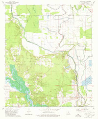
1980 Map of Clear Lake
USGS Topo · Published 1980About this map
Cannisnia Lake Basin and the winding course of the Red River dominate this Louisiana landscape at the intersection of Caddo, Red River, and De Soto Parishes. The map reveals a complex network of waterways, where Bayou Pierre and Prairie Bayou weave through low-lying bottomlands, punctuated by scattered rural settlements like Star Point. This era shows a landscape managed for both extraction and agriculture, evidenced by an Oil Field and scattered Gas Wells alongside modern Fish Farm operations. Social life is anchored by country churches and cemeteries, such as New Friendship Ch and its accompanying New Friendship Cem, while the Pacific railroad line cuts across the northeastern corner. Infrastructure like the Gravel Point Bridge and La Coupe Bridge provide vital crossings over the numerous bayous that define the region's topography.
Find a feature on this map
40 named features on this map. Tap any name to fly to it.
Don’t see what you’re looking for? This feature index may not catch every label — zoom into the map to look around manually.
Map Details
Editions of this 1980 Clear Lake Map
2 editions found
Other maps of this area

1941 · East Point
USGS Topo · 1:31,680

1941 · Bossier Point
USGS Topo · 1:31,680

1945 · Mansfield
USGS Topo · 1:62,500

1947 · Ringgold
USGS Topo · 1:62,500

1947 · Mansfield
USGS Topo · 1:62,500

1948 · Coushatta
USGS Topo · 1:62,500

1948 · Caspiana
USGS Topo · 1:62,500

1955 · Shreveport
USGS Topo · 1:250,000

1955 · Caspiana
USGS Topo · 1:62,500

1956 · Shreveport
USGS Topo · 1:250,000