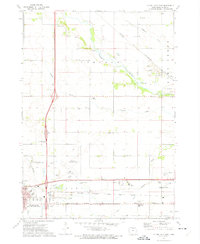
1972 Map of Clear Lake East
USGS Topo · Published 1975About this map
The Winnebago River meanders across the northern reaches of this Iowa landscape, carving a valley that separates the rural townships of Lincoln and Lime Creek. This era of the early 1970s shows the growth of the transportation and agricultural corridor between Clear Lake and Mason City. The presence of the Mason City Municipal Airport and the Iowa Terminal railroad highlights the region's importance as a regional transit hub, while the Chicago and North Western line provides a parallel heavy rail connection. Local community life is anchored by landmarks such as the County Home and the Fairground on the outskirts of Mason City. Genealogists will find the Lincoln Cem and Memorial Park Cem clearly marked, alongside smaller rural features like the Townhall and several active Quarries and Gravel Pits that supported the local infrastructure.
Find a feature on this map
41 named features on this map. Tap any name to fly to it.
Don’t see what you’re looking for? This feature index may not catch every label — zoom into the map to look around manually.
Map Details
Editions of this 1972 Clear Lake East Map
This is the sole edition of this map. No revisions or reprints were ever made.
Other maps of this area

1954 · Mason City
USGS Topo · 1:250,000

1957 · Mason City
USGS Topo · 1:250,000

1958 · Mason City
USGS Topo · 1:250,000

1959 · Mason City
USGS Topo · 1:24,000

1959 · Mason City
USGS Topo · 1:62,500

1959 · Hanford
USGS Topo · 1:24,000

1972 · Clear Lake West
USGS Topo · 1:24,000

1972 · Manly
USGS Topo · 1:24,000

1972 · Fertile
USGS Topo · 1:24,000

1972 · Burchinal
USGS Topo · 1:24,000