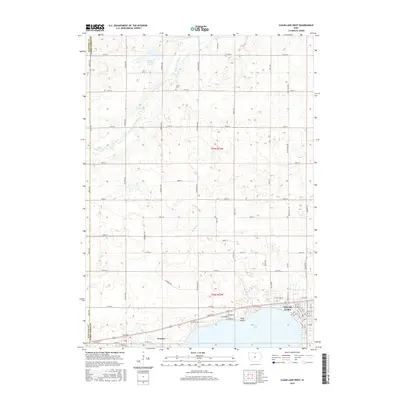
2015 Map of Clear Lake West
USGS Topo · Published 2015About this map
Ventura and the western reaches of Clear Lake anchor the southern portion of this landscape, where the waters of the lake meet the shoreline at Reilly Point. The map captures a transition from the structured street grids of these lakeside settlements to the expansive agricultural sections of Hancock and Cerro Gordo counties. To the north, the hydrology is dominated by the Winnebago River and the Mallard Marsh Swamp, illustrating the low-lying prairie terrain that characterizes this part of northern Iowa. Local history is reflected in the naming of rural infrastructure, such as Buddy Holly Pl, a local landmark road, and the inclusion of the Grant Cem. The network of section-line roads, including Apple Ave and Balsam Ave, provides a framework for the rural homesteads that dot the plains between Willow Cr and Clear Cr.
Find a feature on this map
67 named features on this map. Tap any name to fly to it.
Don’t see what you’re looking for? This feature index may not catch every label — zoom into the map to look around manually.
Map Details
Editions of this 2015 Clear Lake West Map
This is the sole edition of this map. No revisions or reprints were ever made.
Other maps of this area

1954 · Mason City
USGS Topo · 1:250,000

1957 · Mason City
USGS Topo · 1:250,000

1958 · Mason City
USGS Topo · 1:250,000

1972 · Clear Lake West
USGS Topo · 1:24,000

1972 · Fertile
USGS Topo · 1:24,000

1972 · Burchinal
USGS Topo · 1:24,000
1972 · Clear Lake East
USGS Topo · 1:24,000
1972 · Fertile SE
USGS Topo · 1:24,000

1972 · Pilot Knob
USGS Topo · 1:24,000
1972 · Ventura Heights
USGS Topo · 1:24,000